No. 58 - THE MODERN NEW ALRESFORD TOWN PLAN 1964
the first being by Godfrey de Lucy c1200.
 New Alresford parish is one of the smallest in the county. Its five surrounding neighbours are jointly twenty five times its size but with less than half its population between them. Since it first received its present title nearly eight hundred years ago it has remained,, huddled around its three main streets, in the north-west corner of the parish, virtually unchanged until well into the present century. Fires wreaked havoc time after time so there remains little that is really old.
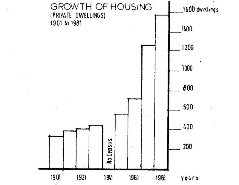
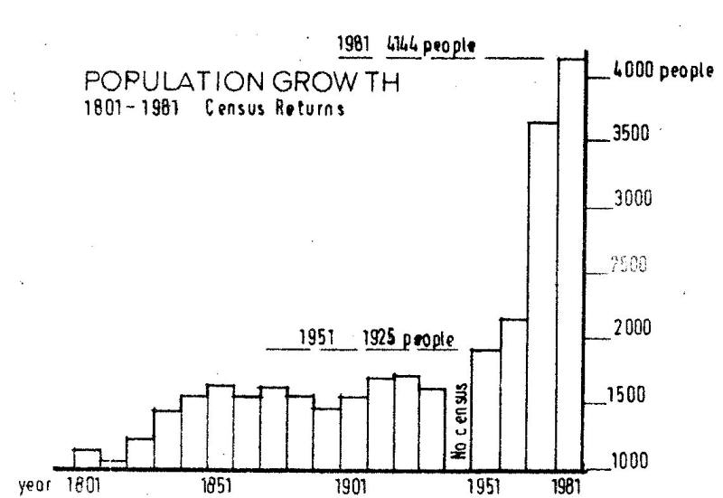
 We cannot, be certain of its size and population prior to the last century but the census figures from 1801 on reveal little change throughout the next one hundred years. There was slow development in the next thirty years during which time one hundred and twenty houses were built. Strangely, in spite of this, the population dropped slightly. Most of this development took place in the south-west quadrant of the parish, in the triangle bounded by the road to Winchester and the B3046 to Cheriton.
Shortly after the Second World War development in this area increased, with private housing mainly on the perimeter and council estates in the centre, culminating in the early sixties with some two hundred council and fifty private houses. Light industries were established in The Dean and in New Farm Road. In the early fifties one could buy a halfacre plot with road frontage for less than £100 and a three bedroomed house cost around £2500.
 Alongside this development many land marks disappeared, some without regret. Who now remembers the gasholders, the smoky retorts and the evil. sulphurous, smell that pervaded The Dean? One could go to the gasworks on a Saturday morning and buy a large sack of coke for 2/6(12p), Warwick. Trailers now occupy most of the site. Further down The Dean was the turkey farm, whose odours in, the summer vied with those of the gasworks. That too had to go to be replaced with Huxley 's and the Christian Literature Crusade, building. The water tower, a real landiaark on the hill leading to Cheriton, became inadequate and was replaced with a new reservoir on the road to Northington. Who can recall the weekly dose of chlorine and the ruined, cups of tea?
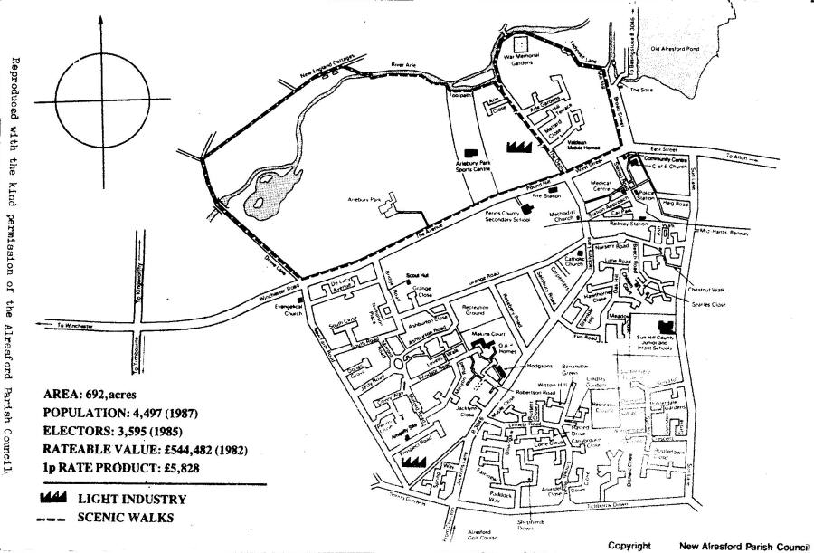
In the early sixties the Planning Authority decided that New Alresford might well expand eventually to a population of 4750. As this meant more than doubling its present number and would thus entail. a huge development programme it was also decided that such a programme must be strictly controlled. In their words "Alresford has a special character and new development should be of a high standard and so designed 'as to maintain and enhance that character". Accordingly in 1964 the County Council Planning Department presented the New Alresford Township Plan and this was adopted two years later. Apart from the huge housing programme the increased population would necessitate new infant and junior schools and extension of the senior school. The main area chosen for developiaent was that part of the parish bounded by the railway to the north, Sun Lane to the east, Cheriton Road to the west and the parish boundary to the south. Seeing it today, it is hard to realise that twenty five years ago, apart from a few scattered houses on the perimeter it consisted of a nursery; allotments and farm fields.
With the huge rise in population it is strange that so little provision was made for industrial development (only three small sites were allocated). In the Winchester Area Local Plan for 1987 we find "no proposals for further industrial development - no sites in the town or on the edge of the built-up areas suitable for development - do not at this stage intend broaching the town's boundaries".
It will be seen that the plan has not been strictly followed. This is understandable for a project of over twenty years duration. It foresaw the need for more off-street, parking and a new library, but both these have still to be resolved. The planned car park below Mill Hill and the public open space, by the river have not materialised. Meanwhile the 1981 census showed that the population had doubled in twenty years and the housing stock more than doubled. The population then stood at 4114. With, development still going at a rapid rate seven years later there is little doubt that we have already exceeded the target of 4750 and the next census in three years will probably reveal a figure well in excess of 5000.
What of the future? We appear to have exceeded the plan of 1964. Some one hundred and twenty five acres of allotments and fields have become a solid block of housing in twenty five years. However, there is still some eighty acres of prime building land to the east of Sun Lane. At present it is all arable fields but no doubt covetous eyes have already been cast upon it as ideal for development. The Winchester Area Local Plan of 1987 clearly limits further industrial development and hints at an expansion of tourism. With road transport only and much of our present population, already commuting and no sign of improved parking facilities, must we now cry Halt?
© S.H. Pullinger - November 1988.