ALRESFORD AT DOMESDAY
by Raymond Elliott
At Gloucester at midwinter in 1085 the King, after deep speech with his Counsellors ordered that a detailed description be made of all England; it was to cover the lands of every shire, the property of every magnate in fields, manors and men - whether slaves or freeman, cottagers or farmers - in plough teams, horses and other stock, in services and rents. The inquiry to be made in each shire before commissioners who had no personal interest therein, and later checked by a second group of commissioners. Then returns to be drawn up in counties and hundreds and the completed survey included most of the country except Durham, Northumberland, Cumberland and Westmorland which were not yet part of England. Nine centuries later the Domesday Book, scrutinized continually by scholars and historians alike is still a vital prime source of information in understanding the beginnings of our rich English history.
'Dooms' is said to be derived from the Anglo Saxon for 'legal documents and laws'. Many transcriptions have been made of the survey and in the most modern work prepared by John Morris and edited by Julian Munby and published by Phillimore & Co. in 1982 we read, under Hampshire, of Alresford as follows :-
LAND OF THE BISHOP OF WINCHESTER
In FAWLEY Hundred
Walkelin Bishop of Winchester holds ALRESFORD in lordship. It is and always was in the Bishopric. Before 1066 it answered for 51 hides; now for 42 hides. Land for 40 ploughs. In lordship 10 ploughs;
48 villagers and 36 smallholders with 13 ploughs 31 slaves; 9 mills at £9. 3.0d. Meadow, 8 acres; woodland at 10 pigs pasturage; from grazing 50d; 3 churches at £4. They paid £6 a year, but they could not bear it. Robert holds 3J hides of the land of this manor; Walter 2 hides; Durand 4 hides in Soberton and 6 hides in Beauworth; an Englishman 1J hides. They have in lordship 6 ploughs. 17 villagers, 6 smallholders and 19 slaves with 6 ploughs. A mill at 20s; meadow, 6 acres.
Wulfric Chipp, Robert's predecessor, could not go whither he would, nor could Osbern, Walter's predecessor; nor Edward and Alric, Durand's predecessors.
Value of the whole manor before 1066 £40; later £20; now, the Bishop's lordship £40, Robert's £4, Walter's 40s, Durand's £11.
The description of Alresford refers to the 'liberty of Alresford' which, quoting from the Victoria County History Volume 3, page 349, states "Domesday Book shows quite well that it comprised the two modern parishes of New Alresford, Old Alresford, and Medstead, and perhaps Wield, for no less than three churches are included in the extent, representing the churches of New and Old Alresford and Medstead, and leading to the inference that New Alresford and Medstead were settled villages with separate churches".
This is also confirmed by Arthur R. Green and Phyllis M. Green in Saxon Architecture and Sculpture in Hampshire.
Birinus receiving episcopal consecration from Pope Honorius I re-established Christianity in Wessex and baptized King Cynegils in 635, and arising from his conversion to the Christian faith the king granted forty 'mansae 1 at Alresford to the Church at Winchester. On succeeding his father in 641 King Cenwalth four years later ordered the church at Winchester to be built and two years after he himself also accepted the Christian faith and was baptized. A number of Anglo Saxon Charters have survived confirming this royal grant, i.e. by King Ine in 701, King Egbert in 825, King Edward (son of King Alfred) then King Eading and also King Edgar in 946, and the Bishop of Winchester was in possession in 1086, still holding the forty two hides or mansae of which seventeen were leased to various tenants. There were now three churches in the Liberty, being the churches of New Alresford and Old Alresford and Medstead, confirming the establishment that together with a settlement at Old Alresford, New Alresford and Medstead were also settled villages with their own separate churches.
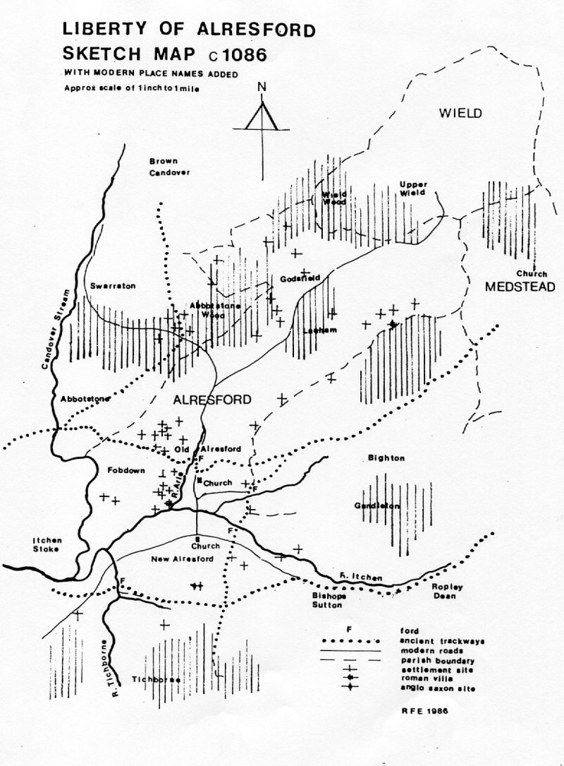
The boundaries of the Liberty of Alresford have been painstakingly studied by Dr. G.B. Grundy and are to be found basically all as the modern parish boundaries today - see attached sketch map - and there is little doubt that the successive Bishops of Winchester had managed and developed the Liberty to the great benefit of the inhabitants and themselves. These large acreages of south sloping pastures, fertile arable lands and productive woodlands reaching down to the clear rivers and spring waters arising from the chalky subsoil were thus much occupied and successfully farmed for many centuries.
From records held by the Royal Commission on Ancient Monuments and the Hampshire County Museum together with the Hampshire Record Office it is established that central Hampshire - including the Liberty of Alresford - has been occupied, and farmed, since the Iron Age and perhaps earlier; and much of this evidence would have been clearly recognized as such on the ground at the time of the Domesday survey. Statistically the boundaries of the Liberty contain some ten Bronze Age barrows, twenty- four occupational sites and enclosures of Iron Age or Romano British settlements, two Roman villas and two Anglo Saxon settlements, and more evidence will quite possibly be identified and uncovered in the future. The concentration of ancient settlement sites on the south facing slopes such as Fobdown and Lanham is quite noticeable, and this is repeated in other parts of Hampshire; no doubt the Anglo Saxon occupation of Old Alresford lies below the buildings and houses existing in the village today. Whilst one accepts the fact that the finding and examination of archaeological evidence is a continuing phenomenon, it is also noticeable that up to now there are only two recorded Anglo Saxon sites, both on the high land of New Alresford, i.e. adjacent to the Sunhill School complex and the parish church. The excavations in the New Alresford area are identified as a domestic collective settlement site of the Iron Age to Romano British period, which also has further evidence of use as a settlement during Anglo Saxon times.
It can be added at this stage that traditionally from later written records, the rich lands of Old Alresford have always been successively farmed whilst New Alresford has developed as the 'industrial' part of the estate. Old Alresford for many centuries was known as Alresford Forum or Manor and New Alresford was known as Alresford Borough or Burgos.
Examining the boundaries it is noted that the southern junction with Tichborne was placed on the ancient trackway from Southampton and Winchester through to Alton and London which runs from the un-named ford at the south western corner of Alresford and passing along the present roadway known as Tichborne Down; this is identified as a summer route and also some time later referred to as the Pilgrims Way. The eastern boundary, adjacent to the parish of Bishops Sutton, was also placed on an ancient trackway running northerly from Bramdean, identified as the Hagsway, and (before the construction of the causeway which formed the enlarged Fish Pond) it crossed the streams from Ropley and Drayton at Woodford and Torna Ford respectively. These two fords, separated by the higher ground containing Wibba's Barrow, were in constant use for many centuries on the north south route but were 'drowned 1 by the rise in the water level consequent on the completion of the Fish Pond in c1200 Ecclesiastical records concerning the rivers and streams in the Alresford valley always refer to the modern Arle, i.e. flowing westwards from Ropley, as the Itchen, and the present Itchen, i.e. flowing northwards from Cheriton and Tichborne, as the Tichborne. Accepting this primary source of information, it would be logical to refer to the Old Alresford stream as the Arle, as this flows from Alresford Manor, and the remaining tributary would be the Drayton. Remember, in 1086, all these rivers were flowing through the extensive Alresford marshes or wetlands undisturbed except for regular seasonal floodings, but such constant flow of clear spring waters would have been of much comfort and benefit to the inhabitants. However, in placing the river Arle through the present village green at Old Alresford we find we are now on the site of the original 'Ford of the Alders'. This will be reaffirmed later as it must be understood that this ford, the Alders Ford, was in constant daily use at the time of the Domesday survey; and we know that alder trees can still be found growing in the wetlands of the Alresford valley. It is possible that this original Arle stream diminished rapidly when the new pond embankment was completed in c1200 causing a notable physical change in the basic water level, also the main traffic route switched from through Abbotstone to along the causeway to New Alresford, and arising from this the local influence, over the years, probably gradually changed the names.
It must be understood that Alresford has always been on an important main historic trading and supply route from Southampton to the north and east of Wessex and England and the identified trade routes or trackways - shewn still in existence on the maps today - would have been in constant use at the time of Domesday. The main road from Winchester passed along the Itchen valley rising up to and through Abbotstone; from here one route continued along the high ground passing the Iron Age enclosure known today as 'Olivers Battery 1 and proceeding onwards to the North. The main road itself however passed eastwards over Fobdown then downwards (passing through modern Manor Farm) and crossing the marsh and river at the Ford of the Alder Trees, situate and known to us all as the village green at Old Alresford. From here the traffic climbed again passing through Bighton and over the high ground to Medstead and on to Alton and London. The southern route, as previously described, kept to the Itchen valley, passed the site of The Bush, and along the southern boundary of Alresford, then passing through Bishops Sutton and Ropley before climbing again to meet the main trackway at Medstead. And we can be certain that the amount of traffic on these busy trackways would have assured that the name of Alresford was well known to all travellers through central Hampshire since earliest times, and the traffic at the time of the Domesday survey would be steadily increasing. Incidentally, at the junction of New Farm Road with Spring Gardens the narrow passageway which travels in a north easterly direction between the industrial estate and the gardens of Jacklyns Close is identified as the old Saxon trackway serving Alresford and leading up the hill to the Saxon settlement and the southwest corner of the parish churchyard.
The Manor of Alresford held nine mills at the Domesday survey, but the precise location of each has not been determined, and if one accepts the premise that the correct interpretation should be 'millstone' and not just 'mill' the picture is still not clarified. However, if we contemplate for a moment on the establishment here of nine mills, this would have formed at that time a considerable industry with a prodigious output for such a small community, even if only sixty or seventy percent were operating at the same time And dwelling further on this point one would assume that these Alresford mills were situated in the central point of a large catchment area, perhaps being developed by the Bishops of Winchester as a policy to expand and exploit the products of his many Hampshire estates by concentrating production in one area. Such mills would concern corn and grain, together with fulling and felting with consequent weaving and tanning etc. and so on. Also the substantial income from the nine mills and following activities would add greatly to the Bishop's coffers, the value of his estate at the same time being most welcome work and employment to the good people of Alresford. The mills that were working at the time of Domesday probably fell into disuse at the construction of the causeway in c1200, mostly due to the significant change in the level and flow of water through the marshlands and its rivers. This is indicated from a record in early 1200s stating that 'a fulling mill seems to have existed in a state of decay at New Alresford 1 and a year later it is further recorded that 'the mill has been removed and its mill pond filled up'. A new generation of mills then became established in the Alresford valley.
Referring back to the Alresford entry in the Domesday Book it could be deduced that some five, perhaps, six hundred people were living and working in the Liberty in 1086, no doubt spread out in the three settlements of Alresford Manor, Alresford Burgos and Medstead, and that the value of the Liberty had considerably increased since 1066. It will be noted from this entry in the Domesday Book that the value given for the time of King Edward was £40., quickly dropping to £20. soon after the Conquest. This great devaluation of some properties recorded in the Survey is described by historians as due to the passage of Norman troops on the march after Hastings as successive parts of Wessex were occupied. We must remember that historically all armies on the march, whether victorious or otherwise, always lived 'off the land' taking food and shelter as they required, and confirmation of the route taken by the Norman troops has been plotted across Wessex by extracting in sequence the known severe drop in value of the various pieces of land. It is known and confirmed that Alresford suffered damage and consequent devaluation from the passage of reinforcements that had landed near Chichester en route to their rendezvous with William north of Winchester. Happily we note that Alresford had made a rapid and successful recovery by the time the Survey was carried out, probably ably assisted by that prime authority, the Church at Winchester.
So one can envisage Alresford at the time of the Domesday survey as a thriving community in which, under the careful management of the Bishops of Winchester, success was assured. The rich farming lands coupled with the produce of the several mills, excellent pasturage, good farm produce and the traditional care of travellers formed a recipe for satisfaction; and later this desirable setting encouraged the Bishop to improve his property by forming the causeway, enriching the fish pond supplying his new palace at Bishops Sutton and at the same time modernizing his trading centre by reconstructing the market place at the Borough of Alresford.
In the meantime William and his Bishops decided on a policy of Church building to serve and instruct the population throughout the country, as can be confirmed by the several Norman churches erected at that time which are today so carefully conserved in all towns and villages throughout England. In the Liberty of Alresford one can suggest from the Domesday entry of "3 churches at £4. They paid £6. a year, but they could not bear it" that all was not well in Alresford and that much work and building was urgently required. Of the present churches in the Liberty we unfortunately have no information or visual evidence of the early structure of the St. Mary the Virgin mother church at Alresford Manor, but we can all today see and admire the handsome Norman stone arcade which embellishes the extension to the daughter church dedicated to St. Andrew at Medstead. In the Church of St. John the Baptist at New Alresford reconstruction is also evident in the Norman ground stage to the west tower of the Church, confirming this upsurge in the consolidation serving the Christian faith. Built into the external elevations of this ground stage of the Tower are two very small Saxon roods, each about twelve inches high and each placed at high level. The one above the original doorway in the north elevation is much defaced and cannot be described. On the West elevation, also at high level, and above the present main doorway the second rood consisting of a single stone in the form of a cross with the figure of Christ in high relief is identified as a piece of Saxon sculpture of immediate pre Conquest date 1050-60 AD. This small rood would have been seen and known by our Saxon forebears as they attended divine worship in their own church before and after Domesday and perhaps in its own way helps to preserve a direct and positive visual link, stretching over a period of nine hundred years, between these Saxon ancestors and all the residents in the very much larger community of Alresford today.
RAYMOND ELLIOTT FEBRUARY 1986.
Copyright.